- Last Update09-Jul-2026


- Tweet
-
What routes are vessels using to cross the Strait of Hormuz?
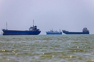
LONDON — Traffic through the Strait of Hormuz, a vital waterway between Iran and Oman, has been heavily disrupted since the start of the Middle East war in late February.
Daily crossings are currently around a third of pre-war figures, with the situation further complicated by rerouted shipping lanes and the ongoing risks posed by sea mines and attacks on vessels.
Here is what we know about how vessels are currently crossing.
What are the different routes?
Vessels crossing the strait are using at least two different routes.
One is the Iranian route, a designated corridor in Iran's waters in the northern part of the strait near Larak Island.
Around 32 percent of ships crossing the strait currently use this route, data up to July 1 from maritime tracking firm Kpler shows.
The second route is the Omani route, a very narrow southern passage "constrained by the Omani coast on one side and mine-risk areas on the other", according to Kpler analyst Ana Subasic.
Around 23 per cent of vessels currently cross the strait using this temporary route announced in June and coordinated by Oman, the United Nations and the International Maritime Organization (IMO).
The Joint Maritime Information Centre (JMIC), run by a Western naval coalition, as well as NATO's Naval Cooperation Guidance for Shipping (NCAGS), also offer guidance on using the route.
Since the start of the war, around 46 per cent of vessels crossed the strait with their transponders turned off, according to the Kpler data, making their itinerary difficult to track.
Analysts told AFP that vessels recently crossing with their transponders turned off tended to favour the Omani route.
They likely turned off their transponders to avoid "broadcasting their position ... while passing within Iranian reach," Subasic told AFP.
Where were recent attacks?
At least five commercial vessels have been attacked since a memorandum of understanding was signed on June 17 between the United States and Iran.
These attacks have been carried out against ships transiting the strait using southern routes, which Iran has said it does not approve.
Of these, three tankers were hit off Oman and the UAE between Monday and Tuesday, according to the IMO, prompting a renewed exchange of strikes between the US and Iran that led to US President Donald Trump saying the ceasefire was over.
How has traffic changed since the war?
Before the Middle East war, vessels crossed the strait freely via the Traffic Separation Scheme, a two-way route through the centre of the waterway adopted by the IMO in 1968.
These designated shipping lanes saw, on average, 120 daily transits in peacetime, but are not currently in use because of the risk of sea mines.
Shipping experts have said that the strait was unlikely to return to normal before traffic through this main corridor was restored.
However, Tehran has insisted there will be no return to pre-war arrangements, and said in June that Iran and Oman were considering charging costs related to operating the strait.
What do ships have to do to cross?
Vessels crossing the strait must follow different procedures depending on their chosen route.
The Iranian route is administered by Iran's Persian Gulf Strait Authority (PGSA), which earlier in the war received fees from some vessels that were subsequently allowed to cross.
To transit, ships must submit an application to the PGSA, which, if successful, grants them a permit for a single passage valid up to five days.
This is a stark change from peacetime norms. Moreover, the UN Convention on the Law of the Sea guarantees freedom of navigation for ships in straits used for international navigation.
Iran, however, never ratified this convention.
For the Omani route, ships are expected to "coordinate with the relevant coastal state, keep their transponders on, and conduct their own risk assessment", Subasic told AFP.
NCAGS coordination is encouraged but not mandatory, official guidance says.
Ships passing through this narrow corridor often cross in groups to avoid congestion and collision.
Latest News
-
 Oil prices jump 5% after Trump says Iran ceasefire over
-
 Syria President Says Wants France to Be 'Primary Partner'
-
 Explosions Rock Damascus, Wounding 18, as French President Macron Visits Syria
-
 Iran Foreign Minister Says US Threats are an Impediment to Deal-making
-
 Trump to meet Ukraine, Syria leaders at NATO summit — White House